HDT Section 1 Arches
I begin my hayduke adventure naiively. It is winter and the temperatures are low this weekend. I plan to start section 1 and make my way from the northern end of arches to Moab. On the drive down I here a terrifying noise on I-70 just past Green River. Pulling over on the side of the interstate, I discover that my bald tire is shedding wire mesh and it had been flapping around. Somehow the tire was still holding air. I exchange for the spare and continue to Moab.
In Moab, I take my car to the tire shop. They allow me to leave my car there for the weekend and will leave the keys on the floor for me when I return from my trek. I keep the fob so I can enter the car. I now walk around town with my backpack and run a few last minute errands. Finally, I’m ready to start my hike. It’s about noon on a Friday.
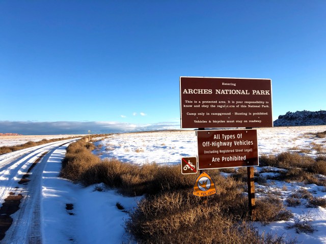
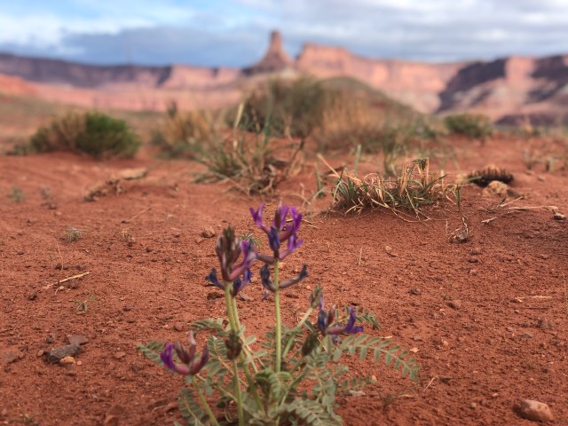
In town I start hitching and it doesn’t take long before a van picks me up. The young couple asks where I’m heading and I tell them it’s the northern end of Arches NP. They are both from out of state and unfamiliar with the area. They aren’t sure where they are headed. They drive to the visitor’s center which is not really where I want to be. I try to explain this, but it doesn’t matter. I’ll make this work. The federal government is under a partial shutdown at this time. The main road through arches is closed due to snow and no funding for plows. At the visitor’s center, I scurry from the parking lot up a hill back to highway 191. I stand there with my thumb out and the same van passes and picks me up again. They clearly don’t have a set itinerary and we chuckle about this. I tell them where I’m headed. While planning the trip I identified the GPS coordinates directly west of the hayduke start along highway 191. I use my phone to navigate them north on 191 to the location. When google maps says we have arrived, the couple is skeptical. There is no pull out or trailhead, just the side of the road. A better proper start would be the north klondike bluffs trailhead, but this seems like a more direct starting location. Eventually they find a pull out within a half mile of where I want to be. It’s close enough. I’ll make this work. Finally starting my hike I walk along the dirt road to the North Klondike Bluffs trail system. This is a popular mountain bike trail system. The area is very well signed. There are several trailheads throughout the area and each trailhead gives a detailed map of the trail system with a “you are here” indicator. It’s very difficult to get lost in this area, but I can always find a way. The trails themselves are a little hard to find in the snow. Some have been more identified by fat tire snow bikes. I use my compass to make my way in the general direction towards salt valley road, the proper start to the HDT. Sometimes the trail is marked with paint on rocks for the mountain bikes. I occasionally lose the trail temporarily and then find it again.

As I make my way over the ridge, I climb up large boulders and through some trees. My exposed camelback bladder on the side of my packed is sliced open by a tree. Water is now leaking all over me. I quickly remove the bladder and try to consume as much of the water as I can. I attempt to rig something to retain half of the water in the now ruined camelback bladder but it’s unsuccessful. I hydroload the remaining water and continue on. As I reach the top of the ridge, I find the trail again and another trailhead sign that tells me where I am. I’m near the baby steps trail and I can eventually see the salt valley road in the distance. With this landmark I trod through the snow and eventually meet the dirt road. After walking on this road a short distance, I soon reach the proper start to the hayduke trail and the north entrance to Arches National Park.
I walk down this road a short distance, turning at a junction and making my way up the road as it climbs. Night is falling at this point, but I want to get as many miles in today as I can.

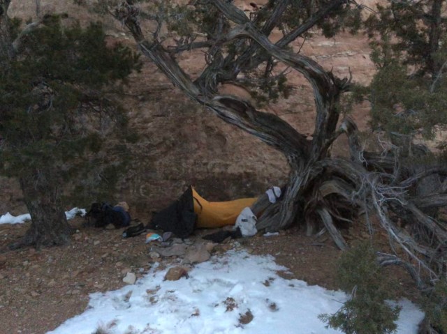
I push myself over the pass, but soon find a place to make camp. The night is cold but I have packed extra warm clothes and a sleeping bag. I boil some snow to fill my water bottles. Melting snow seems to work best when adding water to the snow. It is still a time consuming process and requires a higher fuel load than I would normally carry on a weekend trip. Most of the water sources are likely frozen this time of year, so snowmelt is the best water source. I normally would cowboy camp in this situation, but the low temperatures lead me to set-up my bivy. The protection from the albeit low wind levels creates a little warmth. My gloves, heavy coat, hat, and warm sleeping bag create a warm sleeping experience. It’s much better than I had expected. Historic temperatures indicate the low reached ?? in Moab that night. The downside to camping in this weather is the extra bulk and weight of my warm sleeping bag which is not exactly designed for backpacking conditions.
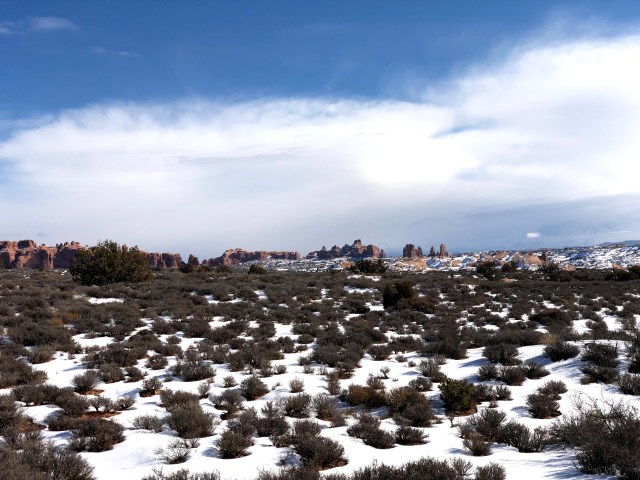
In the morning I make the grueling transition into hiking clothes. It’s difficult to leave the warmth of my sleeping bag, but somehow I get the courage. Packing up and starting to hike keeps me warm. As I continue down this dirt road I am at some point supposed to leave it. The mileage waypoints are confusing in the guidebook. The mileages tell you where to end the section not where to start it. I eventually figure this out along the HDT, but at this point I’m new to this and I’m confused. I miss my turn-off but I discover that if I continue on this dirt road it will lead me to the main road anyway. I think it would be a unique experience to walk the strangely vacant main road during the government shutdown. I continue along the dirt road up and down hills and find fantastic views along the way.

I finally reach the main road in the late morning and I encounter a ranger here. We chat briefly and she asks where I’m headed. I tell her I plan to hike out courthouse wash and make sure she understands that I don’t plan to sleep in the park during the shutdown. I expect to be out of the park and back to my car this evening.

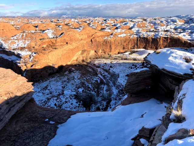
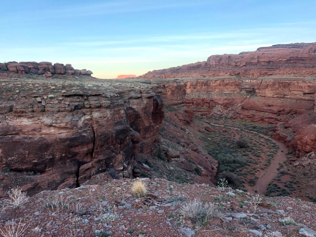
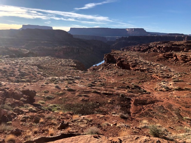
She wishes me luck and I learn that the road has been plowed and the main road is now re-opened. It’s a disappointing realization, I was looking forward to being one of the few priviliged to walk that road. Instead, I have a less than optimal experience. It’s a short (few miles) stretch of road from where I join the main road to where I enter courthouse wash. I enter courthouse wash and I start out above the wash but soon make a path down to the floor. I almost immediately take a wrong turn up a tributary that dead ends. I should have retraced my steps back to where I made the wrong turn. Instead I find a route scrambling up some ledges and find myself at a high point hiking overland across a vast expanse. I continue up and over some hills across the snow for some time.
In a few places I do some scrambling down boulders and keep following my compass south towards the visitor center. Eventually, I cliff myself out and I’m now overlooking a few thousand feet down to the impressive courthouse wash where I belong.
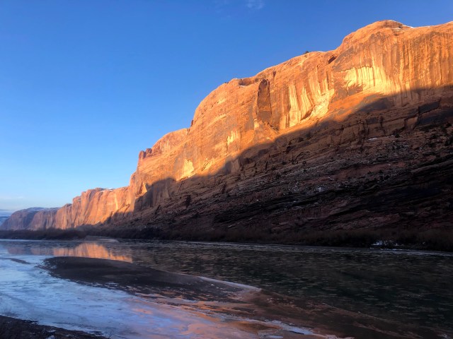
I consult my map and make out the main road in the distance. I decide to continue walking overland toward the main road. I finally arrive and at this point in the day it is now dusk and I am exhausted. I reach the main road and I’m out of water. A nice couple spares some for me and they offer me a ride but I politely decline. A few cars later and I change my mind and stick my thumb out. I decided the hitch might be difficult as it becomes dark so I hurry and call it quits now. It doesn’t take long before I get picked up and I’m not far from my car in Moab. The keys are inside with the receipt just like we arranged. The Moab brewery is closed so I go to Eddie McStiffs and get a delicious veggie burger with a hop rising. Then I drive up Kane Creek road to the first pull-out and spend the night in my car. Sunday morning I wake up and take in the view of the Colorado River.
A few months later, I’ll be hiking up the Kane Creek road. I then make the drive home, stopping for lunch with my friend Janet in Price along the way. I’ll finish section 1 starting from Moab next time. But for now, I’ve got a few miles of the Hayduke behind me.
HDT end of Section 1 and all of Section 2
My trip started by driving from Salt Lake Friday morning. I stopped in Price along the way to borrow a gps device from my friend Janet. The GPS unit would prove useful in aiding navigation at three times during the trek. This would be my first time hiking with a GPS unit. After repeated navigational problems in the Uinta range, the wind river range (Gannett Peak attempt), and Death Valley (Low to High route attempt) it was clear that I was prone to wayfinding errors. In the past I had always relied on a compass, map, and waypoint directions. The experiment of bringing the GPS unit helped ease the fears of myself and my loved ones.
I arrived in Moab and gassed up at the Maverik on the south end of town. I obtained and consumed a carbohydrate heavy breakfast burrito with potatoes in preparation for my 62 mile weekend journey. Gas and carbo-loading was the extent of my Moab errands. I then drove south then west past Newspaper Rock to the Canyonlands Needles district visitor center. Here I cameled up on water. At the visitor center I inquired about leaving my car here for a few days. The true end of HDT section 2 is the big canyon trailhead, but the visitor center is a relatively close alternative end point. The exceptionally friendly ranger asked a few questions about my plans. I simply stated I planned to hike from Moab. I made it clear that I would not be sleeping in the park (which would necessitate a backcountry permit). She recorded my anticipated exit date (Sunday) and gave me a tag to place in my dash. Due to wayfinding issues, my anticipated exit date would not be met. Instead I would ultimately arrive at my car a day late (early Monday morning).
I changed my shoes, locked my car and walked the short distance to the main road. I wasn’t sure if hitchhiking was permitted in this National Park so I tried to be discrete and stay alert for rangers. Thumbing was extremely easy for me at this time and location. The second car to pass me pulled over and asked where I was headed. I responded “Moab. But I’ll go as far as you’ll take me.” The man turned to his wife and asked her what she thought. I waited with anticipation to see if she would approve my presence. All three of us seemed to realize how insulting it would have been if she had said “Naah” and driven away. Instead, she relented and they invited me to join them. Ian and Casey, a couple in their late 30’s from Wisconsin were visiting Moab on vacation. They had visited Utah the year prior and had enjoyed the experience. They felt there were additional sites to explore in the Moab area so they had made a return visit this year. Ian was extremely loquacious and dominated the conversation for the roughly 1.5 hour return trip to Moab. He occasionally permitted Casey or me to chime in with a few brief thoughts. He recognized his tendency for verboseness and I didn’t mind the string of topics he professed.
We arrived in Moab and they dropped me off at the McDonald’s across from the Moab Brewery. Here the road is signed “Kane Creek Road” at this junction of Main Street. From the McDonald’s parking lot I began walking west along the Kane Creek Road. I messaged my wife that I had begun hiking, exchanged some heart emojis, and put my phone on airplane mode to conserve batteries. My goal for the evening was to finish section 1 which would mean about 15 miles from McDonald’s to Hurrah Pass. Fresh and full of energy, I felt confident in obtaining this goal before dusk. I was getting a late start of 3:40 PM with a sunset scheduled for 7:45 PM. Given the easy dirt road walking, I pushed myself to walk at a brisk 3-4 mph pace. I kept some snacks in my pocket that I could consume while walking. My newly purchased water bladder had tubing I could drink from. These accommodations allowed me to minimize stop time and make constant forward progress (CFP).
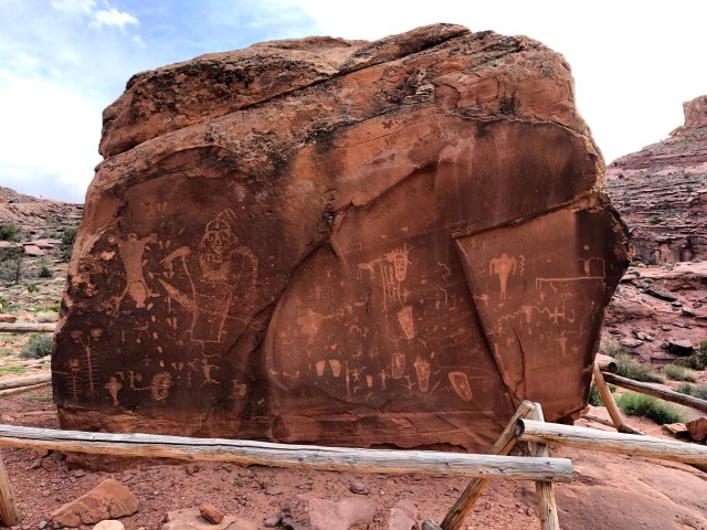
This portion of the HDT was not the most pleasant experience. I was familiar with this road from previous trips and knew what to expect. This area (BLM land) is highly trafficked by ATVs. You will get dusted by those who don’t slow down while passing. I advise wearing a handkerchief or buff around your neck to pull up over your mouth as needed. One nice couple in a sedan offered me a ride which I politely declined. Given the conditions, I should have considered yellow blazing this portion. Yellow blazing is a thru-hiking term that refers to hitchhiking instead of hiking a portion of a route (yellow refers to the color of the road stripe). The highlight from McDonald’s to Hurrah pass is the “Birthing Panel” pictographs which is hard to miss on the right side of the road.
At an ATV staging area I met two men with backpacks and we immediately recognized each other as Haydukers and chatted briefly. There are several primitive but developed campgrounds along this portion. After the last campground, a few miles before Hurrah Pass, I encountered a sign that said “no camping next 6 miles”. I did a self-evaluation while considering time and decided I could maybe push myself 6 more miles. I also wasn’t ready to stop yet. I was a good 1/10 of a mile past the last campground so I persisted on.
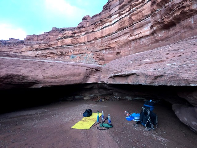
Within a few miles though, just before reaching Hurrah Pass, as the sun began to set, I spotted a nice stealth site off the road. Though I generally try to follow regulations, I convinced myself my minimal impact would not be felt. I warmed some Trader Joe’s Jaipur Vegetables indian packet in boiling water over mashed potatoes and cowboy camped for the night.
My alarm woke me at 6:00 AM. It was still dark with a sunrise scheduled for 6:45. I hurried and packed in the dark. I made myself some cold coffee using starbucks via instant powder and began hiking.
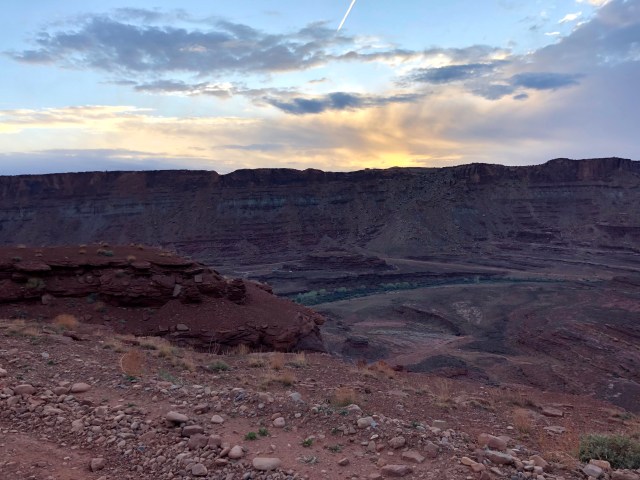
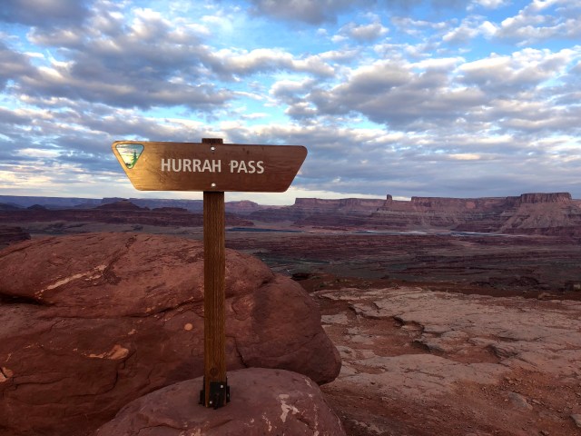
Within a mile, I arrived at Hurrah Pass and began the descent on the other side of the pass with the Colorado River in view.
I continued sluggishly along the dirt road and stopped at a junction under a tree to have a proper breakfast. I quickly made myself some oatmeal and soon passed the next two junctions.
At one point, I reached a four-way junction. The goal here was to stay on the main road, but I went up a wash that soon reached a dead-end. It was possible to continue on foot, but I knew I should stay on a four wheel drive road and this was definitely not a road. I returned to the junction and took another choice. This path took me on a longer trip to a dead-end, a pour-off. I scrambled up but soon reached another pour-off and my current trail was definitely not looking very “road-ish”. I took a GPS reading and it said I was in the wrong spot, so I returned to the junction once again. Finally, I took the last possible choice, this proved to be fruitful. My two wrong choices were an hour detour easily. I continued up the steep road and a few four wheelers passed me. I was doing mile math in my head and realizing I had gotten a little behind schedule. The four wheelers were nice. They asked me if I wanted water and I politely declined. They realized they had lost their cell phone and had to turn around to find it. I kept my eye open along the road hoping to help them find their phone. Once they found it, they passed me again. This time I took them up on their water offer. They gave me plenty of ice cold bottled water which was a huge time saver to not have to stop and filter. The water sources on this stretch were few, far between, and alkaline anyway. I thanked them repeatedly for the water and continued on my way. I followed this road over a pass to some amazing views and continued on.

A few more four wheelers passed and waved to me. I considered asking them if they would be in cell service at any point this weekend. I thought to ask them to pass a message to my wife that I was behind schedule. I thought to do this, but I never got up the nerve to ask.
I was watching my mileage on my phone carefully and using the mileage waypoints in the book to know when my turn-off was.

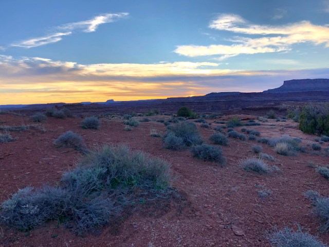
At some point, I left the road and continued down a wash. The mileage isn’t perfect on the phone but I saw footprints indicating I had found the right wash. I continued down the wash as the day was turning to evening. At one point in this wash you reach a huge downpour that you must traverse around. My goal was to reach this downpour. I didn’t quite make it because I found a nice water source about a mile before and decided this was a good place to set up camp so I could spend some time filtering at camp. The water trickled down over a small ledge. It was alkaline. I could tell by the white stains it left on the rocks. I had read that alkaline water can cause upset stomach, but I took my chances. It started to sprinkle rain a little bit. The sun low in the horizon with moisture in the air was the perfect rainbow recipe. I looked with my back to the sun and spotted a rainbow in the sky as I filtered water.

The ground below the water trickle was damp. I made my bed under the ledge in the mud to shield me from the rain.
The moisture made for a colder night than the one prior, but it was tolerable. I set my alarm for early o’clock once again and gave myself just enough time to break camp in the dark and start walking at first light. I soon reached the huge pour off and traversed around it to the left.
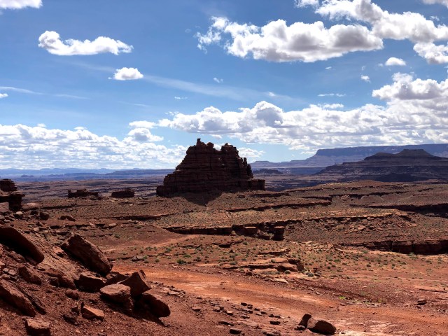
This path led me to another canyon which led me to a road. That road took me to an oil drill site. At this point I followed my compass and found my route down another canyon that led me into the beautiful rustler canyon. Rustler canyon took me to Indian Creek. I walked up Indian Creek about a mile and that’s when things started to get really interesting. At this point, when you leave Indian Creek, you are truly out in the middle of nowhere. Before leaving the creek, I decided my water was pretty low. The water running in the creek was extremely silty. I knew it would clog my filter instantly. I decided to wait until a proper spring, but just in case, I filled a few empty bottles with dirty water. I tried running it through a bandana first but it didn’t help much. I decided to just bring the reddish-brown water with me for emergency supply. According to the route description, it’s necessary to climb and find your way up to the ridge. The climbing can be extremely difficult in some places. A few times, I decided I wasn’t high enough so I backtracked looking for opportunities in the wall to shimmy myself up higher. At one point I took my pack off and stepped on top of it to give myself the height needed to climb up a pour-off. I then hoisted my pack up the ledge using para cord which broke and my pack landed back at the bottom. I then had to downclimb, re-tie my paracord (stronger this time) and repeat the process. A few other spots, I was able to leave my pack on but the weight of the pack and the exposure combined with a few difficult rock-climbing moves made me nervous. Adding in the remoteness of the area, there was a lot of pressure not to die or sprain my ankle here. The guidebook then tells me to reach the unmarked boundary of Canyonlands NP. This is extremely unhelpful because, as the book says, it’s unmarked. So there’s nothing really to look for. It also mentions a chocolate layer cake formation which I think I am looking at but not one hundred percent certain. I spend a lot of time on top of the ridge trying to decide if I am in the right spot. I take a GPS reading and it says I am off. I have to get to the other side of the cake and I struggle to find a route through. After another hour detour of wandering around the chocolate layer cake and checking GPS coordinates, I find a passage and find a view of the colorado river.
At this point, the guidebook references three pyramids. The first two are obvious and I have no trouble finding them. The third, I believe, is further in the distance along the ridgeline and looks nothing like the first two. This confuses me and I spend some time wandering. I have found footprints and this is reassuring, though they lead me the wrong way temporarily. My goal at this point is to drop into what the authors dub “We-hope-so wash”. I hope so too. It looks correct, but I’m not certain. In order to descend into the wash from the ridge, one must find their own way to drop down a series of ledges. At this moment in the day, the sun is getting low on the horizon. Today (Sunday) is my scheduled exit day and I feel tremendous pressure to reach my car. My wife is expecting me to reach cell phone service and make contact today. My boss is expecting me at work in the morning. I’m still several hours from my car plus a five hour drive home and dusk is quickly approaching.
I read ahead in the route description and the rest of the hike seems fairly straight forward to manage in the dark. Once I drop the ledges I follow the wash to a dirt road which will lead me to my car. My biggest concern at this moment is dropping ledges while I still have daylight. The book makes a strong recommendation to make sure everything you downclimb you can successfully climb back up. Just in case you get cliffed out and have to turn back. This requirement gives me pause as I find a route down to the canyon floor. Eventually, I decide that the sunlight is leaving me too quickly and I need to take action and reach the floor quickly. I’m also out of water at this point. I make a decision to chug the untreated putrid red/brown emergency stash from Indian Creek. My thinking is I’d rather deal with diarrhea tomorrow than dehydration today. My focus now is to reach my car. I do some math and estimate I could be reaching my car at midnight easily. I feel badly that my wife is likely starting to worry about me not making contact.
As I drop ledges, I break the “make sure you can climb up everything you climb down” rule. I lower my pack with the paracord a few times and chimney down in some spots. Everything magically worked out, but I could see a few places where a person could easily get cliffed out and not be able to get up or down. I reach the canyon floor and find my beloved footprints again. At this point I feel a connection to these fellow haydukers who are leading me out of the desert. I decide that even in the dark, I can follow these footprints and find the road. It will be a death march, but I’m confident I will make my exit on schedule albeit late. My confidence would soon be shattered. The physical and mental exhaustion and dehydration are wearing at me. “We-hope-so” wash luckily is lush with water this time of year. I take a moment to filter and choke down some food. As twilight turns to night, I’m greeted with sounds of frogs. The wash description speaks of long miles but relatively easy navigation. The only crux is a major junction that requires you to bear right. The book also mentions, and the map confirms, several side tributaries to avoid. The goal is to stay in the main wash until the junction. I don my headlamp and carefully follow the footprints. The footprints are obvious in the sand but disappear over sections of slick rock. There are a few easy pothole obstacles that have to be avoided. My headlamp lacks much brightness. Eventually the trail becomes overgrown, I’ve lost the sound of frogs, and I’ve lost the footprints. I’m reaching a dead-end. I later realize I had veered right into a tributary. Hindsight tells me I should have retraced my steps and found the proper main wash. My fatigue leads to poor decision making and I make the decision to press on with the idea that I’m heading in the general direction of my car. In retrospect, I regret this choice. I climb up a ridge and take a GPS reading. My maps are imperfect for giving precise GPS coordinates. I’m generally in the right spot and I insist if I continue, albeit on the wrong route, I will eventually bisect the dirt road. I continue down to the ridge easily to a canyon floor but I hate losing the elevation I had worked for. From here I try to get my bearings in the dark and I can see a ridgeline forming a bowl around me. I diligently take GPS readings. Rather than work towards the road on this route, which would be a traverse of unknown difficulty, I reason with myself to make my way to the proper route. I find myself up on the ridge beneath a cliff face. I walk around the sheer face trying to find a passage up. I eventually find a low spot and make my way up. In the dark, I survey the landscape. From this ridge, I decide that I either need to drop down to the next canyon or follow the ridgeline to the road. The easier route is not obvious in the dark. It’s 11:30 PM at this point and I’ve been hiking since 6:00 AM. I’m experiencing extreme exhaustion and I fear it is leading to poor decision making. I’ve been using my cell phone flashlight in place of my weak headlamp. This is draining the batteries and I rely on it for navigation. On top of the ridge, I make the decision to call it and find my way out when I have the advantage of sunlight. I have a pit in my stomach but I’m not sure what it’s from. It could be the calorie depletion, a bug in the dirty Indian Creek water, or most likely the guilt knowing my wife is having a restless night panicking about my whereabouts.
As dawn breaks, I take a GPS reading with a fresh mind and study the maps carefully. I realize from this ridge I am sitting right above “we-hope-so” wash and I can clearly see the junction. The route to the floor looks easy enough. It’s a gentle slope of scree with a few boulders. I pack up and find my way down to the floor where I’m greeted by the familiar footsteps. It’s a short mile or so jaunt from the junction to the dirt road. I’m overwhelmed with relief when I finally reach that dirt road. I follow the road towards the visitor center. The hayduke trail is good about alternating between easy dirt road mile buster sections and difficult route-finding adventure climbing. I’m glad to take the easy dirt road route now after what I had been through. The dirt road seems to wind on longer than I want it to. I of course am open to any hitch that comes along. But it’s Monday morning. There are no opportunities. I eventually meet a fellow hayduker Bruno from Chile. We talk for a few minutes about our experiences. He shows me his footprints and I immediately recognize them. He’s the only one who truly understands what we’ve been through. We agree the rock climbing out of Indian Creek was brutally intense. He’s walking in the opposite direction of me to pick up where he left off after his resupply at needles. We wish each other well and I hike the final neverending stretch to the visitor’s center. I reach my car around 9:00 AM and ask the ranger if I can use their phone. They tell me it’s only for medical emergencies but there is wifi available. I use the wifi to get a message to my wife and my boss. My wife had already alerted my boss that I wasn’t coming in to work. I slam some fresh water. I make the hour or so drive back to Moab. Once there, I treat myself to lunch. It’s my traditional veggie burger and Hop Rising. I sit on the patio and they tell me it’s still a little early for Utah’s standards. They have to wait ten minutes before they can bring me my beer.
My legs are beat to hell and the stationary position of the drive back to Salt Lake causes muscle fatigue. I feel accomplished but ashamed that I underestimated the time. If I had only had a few more hours of sunlight to get me out of the wash I could have walked that dirt road in the dark. But I didn’t. I got lost and I was late. Another failure, but at least it wasn’t a rescue.
HDT Section 3
After my last trip’s failure, I was determined to give myself plenty of time to complete section 3. Section three offered me 68 difficult miles from needles to Hite. My wife was understandably adamant that I stay on schedule after the snafu of section two. She urged me to obtain a satellite phone. We briefly look into the possibility of renting one and realize there are some options online but nothing locally which would be needed at this last-minute. I give myself plenty of extra time.
I leave Salt Lake City at about 6:00 PM on Wednesday night and arrive at Hite before 11:00 pm. Just past the turnoff on the right to the Hite marina, I take the first left off Highway 95 on a dirt road. I follow this road for a few miles and pass an occupied camp. A little further I take a pull-out and sleep the night in my Honda CR-V.
Early the next morning, about 7:00, I return on the dirt road to where it meets the highway and leave my car staged here. I cross the highway in hopes to start thumbing my way towards Blanding and ultimately back to the Needles district of Canyonlands NP.

There are few cars out on this stretch of the highway at this early hour. Many that pass are heading the opposite direction. A few cars going the wrong way stop for me and I consider briefly an alternate hitch that would take me through Green River and Moab. This would add about an hour to the drive. A few stop and offer a ride to Hanksville but I’m skeptical that I’ll have much better luck. Had someone offered a ride to I-70, I would have taken it. After about two hours of anxiously standing on the highway, I finally get a ride in the right direction. He’s not going all the way to Blanding though. He takes me as far as he can and then flags down the car behind him and I’m able to get a near seamless ride to Blanding. The hitching is slow going the rest of the day. I spend a lot of time waiting for cars and walking with my thumb out through Blanding and Monticello to get a better position. It takes me about 8 or 9 hitches before I finally arrive at the trailhead at around 3:00. My final hitch says they are going to Elephant Hill trailhead and I tell them that’s where I’m headed too.
When I arrive at Elephant Hill, I consult my map and realize I am at the wrong trailhead and that I should be at Big Springs Trailhead. I realize though that the trails all connect, so I use this as my starting place. I hike up the four wheel drive road to the top of the hill and meet some jeepers. My detailed topographic maps unfortunately don’t include this exact area of the hike but I’m certain the trails all connect. I ask them if they have a park overview trail map. They give the basic NPS brochure which is sufficient to lead me to the proper Hayduke trail. The trail system is complex and well traveled.

I have several options to make my way to Butler wash. Along the way, two Coloradans pass me in their jeep. We chat briefly and they ask me where I’m headed. I tell them Hite and they inform me that it’s a long way away. I agree. It is about 68 miles to my car. I’m determined to finish this trek by Sunday. It’s now Thursday evening and I have three full days ahead of me.

My goal is 20 trail miles per day. I recognize that often my mileage is higher than the trail miles due to route finding. The jeepers are carefully navigating some rocks and I am able to leapfrog ahead of them on foot. A few minutes later they leapfrog me again and hand me an iced gatorade. I continue on and find them at a camp where we chat briefly again and they agree to haul out my empty gatorade bottle with their trash. I’ve diluted the icy gatorade into my camelback bladder. The first 25 miles of this section are dry, so I’m hauling a great deal of water. The additional electrolytes are appreciated.
I soon make my turn up Butler wash and follow it for a few miles before dusk settles and I make the decision to make camp. I’ve clocked 15 trail miles today and I feel it’s an admirable start considering the lengthy hitch that ate my day.

For this trek I had packed my lightweight warm temperature (30+ rating) sleeping bag which had been sufficient on section two. Unfortunately, Thursday night was a miserably cold experience. In the morning I woke to frozen water and frost covering everything including my sleeping bag. I had used my hiking clothes as a pillow which kept them warm enough to make the change out of sleepy clothes tolerable. The brisk morning also becomes tolerable as soon as I break camp and start moving.

I follow Butler wash and only make one brief navigational error when following a sandy wash tributary that dead ends. A GPS reading tells me I’ve gone astray and I retrace my steps back to the junction, taking readings along the way. The proper route is obvious and trodden with footprints when I reach the junction. Back on course I eventually arrive at what the authors term “seldom seen” natural bridge.

At this point the hike requires some scrambling which consumes some time. Immediately after going under the bridge, I encountered an obstacle. The route up appeared straight ahead and obvious as rocks had already been piled by past hikers to achieve more height. I attempt this route unsuccessfully. I tie paracord to my backpack hoping to achieve more height with the goal of pulling my pack up after making the climb. The climb is too difficult and I can’t find the proper hand and feet holds to make it up. I look at other options. First I skirt to the right and find a potential line up. As I start my ascent, my legs start cramping and I feel uncomfortable with the exposure as I struggle to find the additional holds needed to make the ascent. I bail on this route and carefully downclimb back to safety. I return to the obvious path up the middle and make a second failed attempt. I’m feeling urgency, adrenaline, exhaustion, and leg cramping. I pause briefly to collect my thoughts and deal with this obstacle with carefulness. The guidebook says nothing about obstacles. It simply says “make your way up to the ridge”. I tell myself the correct route is straight up the middle based on the stacked rocks. But I can’t manage up and the failed attempts is zapping my energy. Instead I look to the left and scout a possible line up. I find one potential route. It has some exposure and I leave my backpack on. I make the climb up carefully testing handholds for stability along the way. Finally reaching the stable ridge I feel glad to have that obstacle behind me.

I follow some game trails and briefly break to consume some calories. I’m disappointed in my progress so far today and my energy is low at lunch. After making a steep ascent to another ridge, I’m rewarded with a mild downhill/flat descent across the beef basin pasture. I follow my compass carefully and consult my map. My phone mileage is also useful in tracking the guidebook waypoints which includes crossing one dirt road then following another. Along the way I discover a pile of broken pottery.

This area is rich with native artifacts. There are supposedly ruins in the beef basin area but my aggressive schedule does not allow time to explore. I follow the dirt road and descend a wash as instructed in the guidebook. My water is running low and the guidebook suggests some water sources are available. There are many cows in this area which fits with the name “beef basin”. The only water sources I find are those mud and cowpie swamps. Further down the wash I find clear water but I know it is being fed by the cowpie swamps above. I stop to run the water through my filter but it still has a putrid cow funk taste to it. I mask the taste with powdered berry electrolyte drink.
Soon I reach the Fable Valley Trailhead. You can reach this trailhead via dirt roads but it is a long way from any major highway. Nearly all the entries in the register are haydukers and there are very few entries at all. I recognize my friend Bruno in the register whom I had met at the end of section 2. I also identify haydukers “Sochi” and “Fafbab”. Who I would later online stalk when I return to civilization after this trip. Sochi has a good website with his trip reports but no intel at this time for the HDT.
The fable valley trail is extremely well graded and well marked.

The path is clear and very well cairned. The day is nearing its end and I had not made the progress I had wanted. I force myself to push the 3-4 miles to fable valley. This portion of the hike is very beautiful. As I near the fable valley floor I find a nice spot to camp off trail near a water source and I call it a night. This night is not nearly as miserably cold as the prior night.
I wake up early to my alarm before dawn and break camp in the dark. I had filtered plenty of water the night before and dumped the manure tasting water. I quickly finish my descent to the beautiful lush fable valley floor. Again, I know there are many ruins to explore but there is no time in my schedule. I’ll have to return someday and spend more time in this beautiful place.

I take a right at the junction as instructed in the guidebook and then begin the brutal ascent to the ridge. This takes longer than I expect (a recurring theme). The route is steep and endless. It requires much routefinding around obstacles and occasionally over rocks.

There is no difficult exposure or rock climbing required but it is definitely steep and time consuming. I’m reminded of the brutal neverending climb up to telescope ridge in hanaupah canyon in death valley. This climb is not that extreme but there is some mental exhaustion from reaching false summit after false summit. Eventually I reach the ridge. I capture my first view of the Henry mountains with the snow covered La Sal’s far behind me now.

A dirt road takes me to horse (horse thief horse pasture?) canyon and ultimately Young’s canyon.

Youngs canyon proves to be another timesuck. The canyon has major obstacles all of which require detours to the left. The first bypass route is a high route that requires major climbing and it is an extensive bypass.

Along this route I break for lunch. Along Young’s canyon I find that the guidebook dismisses the extensiveness of some bypasses and overexaggerates the difficulty of other bypasses. For example, after the “notch” the author describes a brutal descent down loose scree. I find the notch and the descent well cairned and a straightforward nice trail descent. Maybe the conditions have improved as haydukers have established a trail since the original writing. At the top of the notch I even find a cairn with a page from the guidebook sandwiched in the cairn. I must be in the right place.
The other cause of slowing in Youngs canyon is the frequent return to the canyon floor which in places is marshy, overgrown and thick with tall vegetation. For these sections I don my sunglasses to be sure during the bushwack I’m not stabbed in the eye. Finding my way around the “thumb” was not too challenging.

Using intel from Jamal’s across Utah website was also helpful throughout Young’s canyon. The most important thing to remember is to always use the left to bypass obstacles. Once I used the right side after finding a well trodden game trail. I followed this for some time but it eventually cliffed me out and I was forced to retrace my steps which consumed more time. My water levels were low and I found a spring running through the rocks which I told myself was enough filtering. The other tricky spot was at the conclusion of young’s. Again, I bypassed to the left and followed the cairns down to the high waters of Dark Canyon.

The water running through Dark Canyon is very silty. I wished I had gathered more pure water from Young’s before leaving.
At this point, I’m nearing the end of the day and my energy levels are low. I’m experiencing much physical exhaustion from the climbs out of fable valley and the youngs bypasses. The mental exhaustion of route finding and problem solving is also taking its toll. I trek a mile or so down Dark Canyon. The water is deep and frequent crossings are required. The water reaches my waist in places and the trekking pole is useful for stability and testing depth. My pants and shoes are soaked. I end the day prematurely though an hour or so of daylight could have been utilized. I find a decent enough spot to camp and dry my clothes. I’m disappointed with the trail miles I have conquered today which is about ten or so. It’s far short of my goal of 20.
In the morning I continue down canyon making frequent crossings.

I make the decision to hike in my boxers and no socks to keep my clothes dry.

The navigation here is a little tricky and time consuming. A few times I have to briefly retrace my steps. Though Youngs always bypasses on the left, Dark alternates left and right. Sometimes either will work. I use my judgment as I’m constantly scouting a route. Often the path is on a ledge above the water. There is no major dangerous exposure on this section.

Right before Lost Canyon I encounter human beings. It is Sunday morning. The last humans I had seen had been the jeepers on Thursday. I welcome the conversation and we discuss our routes. I ask some information about the climb out via the sundance trail. None of us acknowledge the embarrassing fact that I’m hiking in my underwear. They encourage me to check out Lost canyon and tell me there is pure flowing water there. I ignore their suggestion but I later wish I had watered up before leaving Dark Canyon. I meet some more hikers and converse with them briefly.

Finding Sundance trail was relatively straightforward. I had been given intel from the two hiker groups and they had pointed out the route. When I arrive at the sundance trail however I take a brief wrong turn and follow a stray game trail until it peters out. I take a GPS reading and make my way back to the proper trail. Once on the proper route, the climb up sundance is steep. It is very well cairned though. There are so many cairns that it seems in some spots I have ascent options. I pick my way up and the physical exhaustion sets in again. It is a hot part of the day and the heat is slowing me down considerably. I often take short rests and then push myself further. I realize that my water situation is poor at this time. For some reason, I’ve convinced myself that when I soon reach the top I will find a proper trailhead bustling with cars. This is not true. I tell myself that I will be greeted by crowds of tourists who will share water with me. This is also not true.

When I finally reach the top, I take a wrong turn. I mistakenly follow the ridge above sheep-something? Canyon. I’m taking constant GPS readings but it takes some time before I realize my error. After some work with the compass, map, and GPS I find my way back to the proper route. I tell myself I must be nearing the road and I even think I spot it at one point but I’m wrong. This takes much longer than I think it will. I continue to tell myself that when I reach the dirt road I will be able to hitch my way to the car. This turns out not to be true. My dehydration is becoming unbearable. I take small sips of my little remaining water.

I am always sure to hold some water back just in case. Finally I stumble upon a pothole full of putrid stale water. I don’t care. I kneel down and pound water directly from the dirty source. I feel I’ve quenched my thirst and make the mistake of not filling my containers.
I finally reach the dirt road and begin the long 10 or so mile trek to my car. My math tells me I should arrive at about dusk. The dehydration sets in again. It becomes so bad that my head is pounding and my entire mouth including the back of my throat is sticky dry. It hurts to swallow. I pass an unoccupied camp and I hope for traffic but it never comes. At each junction, I check my GPS and map meticulously. I can’t afford to make a navigational error and risk arriving late to my car. As indicated in the guidebook, I find another pothole right before a junction. Again, I drink directly from the dirty source and fill my empty containers with the silty water. A bit further, just before the airstrip, I wave down a car heading the opposite direction. This is the first vehicle I’ve encountered. I ask him if he could please spare any water. He graciously provides me a few liters. I show him the silty water I had collected to earn pity points. Further now I’m encountering more cars and bicycles. They are all headed in the opposite direction. A bicyclist gives me a few more liters. He’s familiar with the Hayduke trail and we discuss it briefly. Eventually, I encounter a bicycle support vehicle also headed in the opposite direction. They talk to me a bit about my hike and offer me some water. I thank them and tell them I have sufficient water. I jokingly tell them I’ll take a ride to the highway but I know it won’t be a reality.

As dusk settles I get a visual of the highway.
A little further and I can spot my vehicle. It’s a splendid sight. I reach the car, let out a little cheer and throw in my pack.

I make the drive to Hanksville as the sun vanishes. I make contact with my wife and tell her I’ll drive as far as I can tonight but will likely finish the drive in the morning. I find out that Dick’s Grill is open and I stop for a much needed veggie burger and hop rising. They put cucumbers on it and serve it with a pretzel bun. It’s the most delicious thing I’ve ever tasted. I drive to I-70 and continue on towards Price. My fatigue sets in and I call it a night a bit before midnight. I sleep in my car and set my alarm for 5:00.
In the morning, I text my boss and tell him I’ll be a few hours late. I finish the drive home where I shower and head to work. Another relaxing weekend in the books. Time to start planning section 4.
